Multiple rounds of heavy thunderstorms hit the Dallas-Fort Worth Metroplex through Saturday night and into Sunday, dumping up to 6 to 8 inches of rain in isolated areas and triggering flash flood warnings across the region.
The National Weather Service issued a Flood Watch through 4 p.m. Sunday for portions of North Texas near and north of I-20, with rainfall rates exceeding 3 inches per hour in the strongest cells.
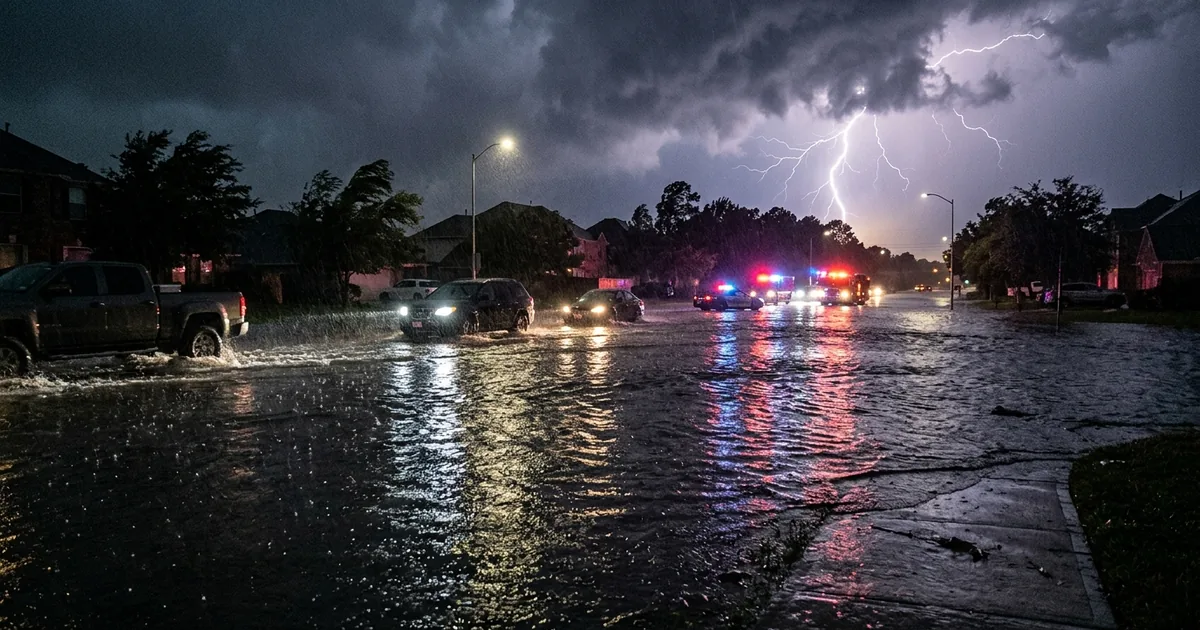
Storms Trained Over the Same Areas All Weekend
The worst flooding risk came from “training” storms, where successive cells moved over the same locations and stacked rainfall totals well beyond what drainage systems could handle. Most areas saw 2 to 3 inches, but the isolated pockets that caught repeated storm passes were the ones in danger.
A Severe Thunderstorm Warning was issued for parts of Dallas and Ellis counties Saturday evening as a strong line of storms pushed northeast through the southern Metroplex. The main threats were rapid flooding and dangerous lightning rather than tornadoes or high winds, though the storm cells moved slowly enough to maximize water accumulation.
The pattern is familiar to anyone who has lived in North Texas. The region’s flat terrain and clay-heavy soil create a worst-case drainage scenario when storms stall. Water has nowhere to go, and urban development has steadily reduced the permeable ground that once absorbed runoff. Every major flooding event in DFW raises the same questions about infrastructure investment, and every year the answers get more expensive.
The Weekend Timing Made It Worse
Flash flooding on a Saturday night compounds the danger. More drivers are on unfamiliar roads, visibility drops in heavy rain, and the instinct to push through standing water kills more people in Texas than any other weather hazard. The NWS repeated its standard guidance: “Turn around, don’t drown.” It is simple advice that too many people ignore every time a flood event hits.
Emergency services across the Metroplex staged swift-water rescue teams as the evening progressed, and multiple low-water crossings were barricaded. The localized nature of the flooding meant that conditions varied dramatically within a few miles, with some neighborhoods seeing minor street ponding while others dealt with water entering homes and businesses.
North Texas Flooding Is Getting More Frequent
This weekend’s storms are not an outlier. North Texas has seen increasingly frequent high-rainfall events over the past decade, a trend that climate scientists connect to warmer Gulf of Mexico surface temperatures feeding more moisture into storm systems that move over the region. The DFW Metroplex added roughly 1.2 million residents between 2010 and 2025, and much of that growth happened in flood-prone areas where developers built faster than municipal drainage could keep up.
The city of Dallas has invested in floodplain buyout programs and stormwater infrastructure upgrades, but the scale of development consistently outpaces the investment. Fort Worth faces similar pressures, particularly in the Trinity River corridor where aging levees protect billions of dollars in commercial real estate.
What to Watch Sunday
The Flood Watch remains in effect through Sunday afternoon, with additional rounds of rain possible before the system moves east. The NWS emphasized that even moderate additional rainfall could trigger flash flooding in areas already saturated from Saturday’s storms. Residents should monitor local alerts, avoid driving through standing water, and have a plan for higher ground if conditions deteriorate.
The storms are expected to clear by Monday morning, but the cleanup in hard-hit areas will take longer. And the conversation about whether DFW’s drainage infrastructure can handle the region’s growth trajectory is one that will outlast any single weekend of storms.