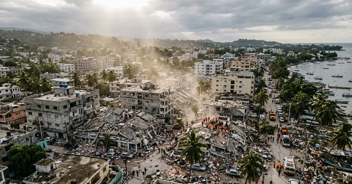
A magnitude 7.8 earthquake struck off the southern coast of Mindanao early Monday morning, collapsing buildings in General Santos, killing at least 16 people, and sending a one-meter tsunami crashing into coastal villages in the strongest quake to hit the Philippines in more than three decades.
The disaster exposes, once again, how fragile infrastructure in rapidly urbanizing Southeast Asian cities remains when the ground starts shaking.
What We Know So Far
The quake hit at 7:39 a.m. local time at a depth of 33 kilometers, roughly 32 kilometers southwest of Maasim town in Sarangani province. Al Jazeera reported Monday that it was the most powerful earthquake to strike the Philippines since 1990, and the shaking was felt across Mindanao, the country’s second-largest island.
General Santos, a coastal city of 722,000 people and one of the Philippines’ busiest tuna ports, absorbed the worst of it. At least seven people were killed and roughly 130 others injured there. A donation center, a building housing a Jollibee restaurant and a Love Radio studio, and a high school in nearby Matanao all partially or fully collapsed. A key access bridge sustained dangerous cracks, threatening supply lines into the city.
Nine more deaths were confirmed across the southern provinces of South Cotabato and Davao Occidental and on Balut Island, mostly from falling debris, a damaged mosque, and a landslide.
Tsunami Reached Shore Within Minutes
The Pacific Tsunami Warning Center issued alerts for coastlines across Southeast Asia, Indonesia, Palau, and as far as southern Japan. A one-meter wave reached shore near the epicenter within minutes of the quake. Smaller waves were measured in Indonesia and Palau before the warning center determined the broader threat had largely passed about five hours later.
The speed of the wave underscored what seismologists have warned about for years: communities in the seismically active Ring of Fire often have single-digit minutes between a major quake and a coastal surge. General Santos sits directly on that fault line.
The Infrastructure Question
This is where the story gets uncomfortable. The Philippines has poured billions into infrastructure under the “Build, Build, Build” program and its successor initiatives. But much of that spending has targeted highways, airports, and metro rail in Manila and the Visayas. Southern Mindanao, despite its economic importance as the country’s agricultural and fishing hub, remains underserved.
The collapse of a high school and a hospital wing in a city of three-quarters of a million people is not just a natural disaster. It is a policy failure that predates the earthquake by years. Building codes exist on paper. Enforcement is another matter entirely, particularly in fast-growing secondary cities where construction outpaces inspection capacity.
NPR confirmed Monday that aftershocks as strong as magnitude 6.5 had already been recorded, raising concerns about further structural failures in already weakened buildings.
What Happens Next
Rescue operations are ongoing. The Philippine military has deployed search-and-rescue teams, and President Marcos Jr. declared a state of calamity across the affected provinces. International aid organizations, including the Red Cross and UNICEF, have begun mobilizing.
But the immediate question is whether General Santos’ damaged bridge can be repaired quickly enough to restore logistics into the city. The port handles a significant share of the country’s tuna exports, and any prolonged disruption ripples through local supply chains that employ tens of thousands.
The broader question, the one that outlasts the news cycle, is whether this quake finally forces a reckoning with building enforcement in the Philippines’ secondary cities. The 2021 Haiti earthquake showed what happens when seismic risk meets systemic underinvestment. Mindanao’s story is disturbingly similar.
For the 200-plus people injured and the families of the 16 confirmed dead, that policy conversation is already too late.