The remnants of Tropical Storm Arthur are dumping catastrophic rainfall across the Gulf South on Thursday, with forecasters warning of life-threatening flash flooding from Louisiana through Georgia even as the storm itself has lost its tropical classification.
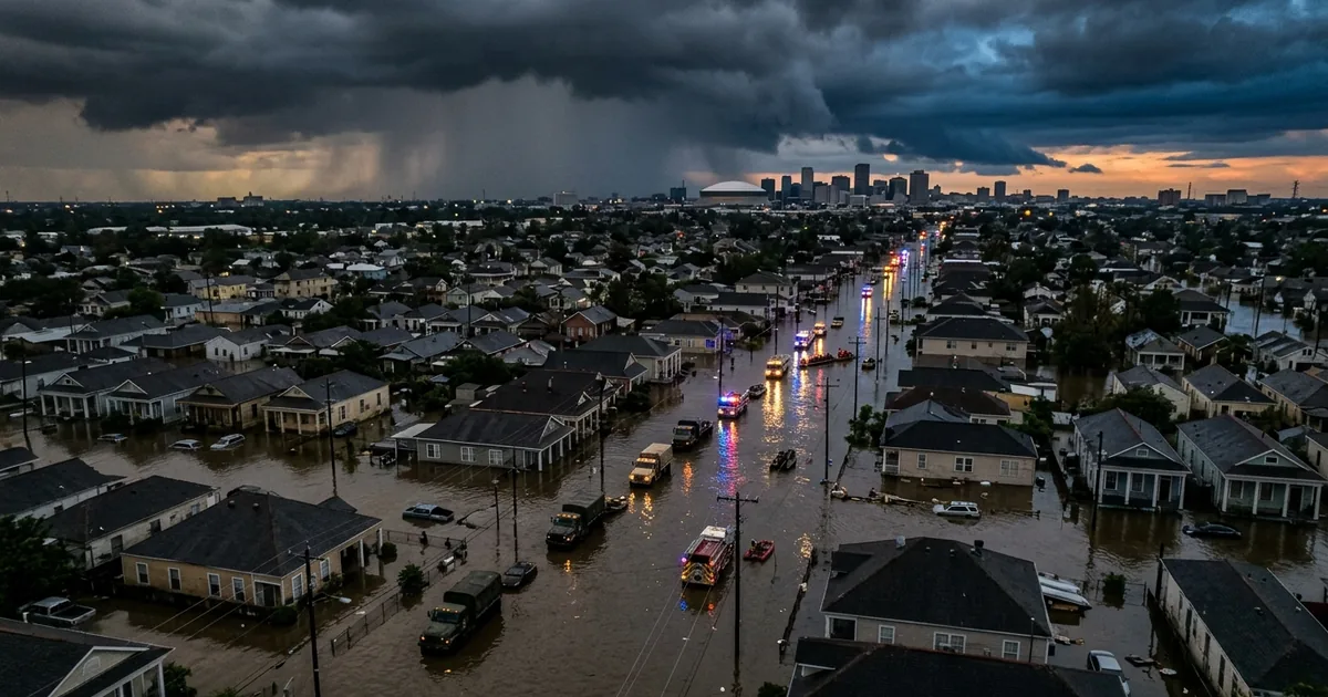
New Orleans, a city that knows what water can do, is bracing for the worst of it overnight and into the morning.
The Rainfall Numbers Are Staggering
Arthur made landfall along the Texas coast earlier this week as the first named storm of the 2026 Atlantic hurricane season, then weakened to a post-tropical system as it pushed eastward. But losing the tropical label has not diminished the threat. The National Weather Service is forecasting 5 to 10 inches of rain from the upper Texas coast through Louisiana, Mississippi, Alabama, western Georgia, and the Florida Panhandle, with isolated totals approaching 20 inches in the hardest-hit corridors.
Flood watches now stretch across a massive swath of the South, covering Houston, New Orleans, Jackson, Birmingham, and Atlanta. The heaviest rainfall is expected to arrive in the New Orleans metro area overnight Wednesday into Thursday morning, with the most intense bands saturating a corridor from the River Parishes through Baton Rouge and across the northshore into coastal Mississippi.
New Orleans Prepares for a Familiar Fight
City officials spent Wednesday lowering canal levels, cleaning catch basins, and staffing pump stations ahead of the rainfall. The preparations reflect a hard-earned awareness of what happens when this much water hits a city that sits largely below sea level with an aging drainage infrastructure that has been tested repeatedly by storms far weaker than this one.
The specific concern is the ground saturation factor. Local forecasters warned that already-wet soils across the region will quickly amplify runoff, meaning even moderate sustained rainfall rates could produce considerable flash flooding. The St. Tammany Parish rivers are a particular focus, with water levels already elevated before the heaviest rain arrives.
For the broader Gulf region, Arthur’s track tells a familiar story about how post-tropical systems can be just as dangerous as their named counterparts. The storm may have lost its defined circulation, but the atmospheric moisture conveyor belt it created continues to pull tropical air northward, feeding rainfall rates that overwhelm drainage systems designed for far less.
Houston Got Lucky, but the Threat Moved East
Houston, the city that bore the brunt of the storm’s initial forecasts, ended up with a better outcome than expected. Arthur’s landfall track shifted slightly, sparing the metro area the worst flooding scenarios. But the relief in Houston means the rainfall concentration has shifted eastward, dumping the heaviest precipitation exactly where drainage infrastructure is most vulnerable.
The timing compounds the danger. Overnight flooding is particularly deadly because residents are asleep and less likely to receive or act on emergency alerts. The National Weather Service has issued specific warnings about the overnight rainfall window, urging residents in flood-prone areas to have evacuation plans ready and to avoid driving through standing water.
What This Storm Season Means
Arthur’s arrival as the first named storm of the season, forming before the traditional June 1 start of hurricane season activity, fits a pattern that climate scientists have been tracking for years. The Gulf of Mexico’s water temperatures are running well above historical averages, providing the kind of atmospheric fuel that turns tropical disturbances into named storms faster and earlier than the models predicted even a decade ago.
The previous major flooding event in Texas just weeks ago at the Guadalupe River demonstrated how quickly water events can turn deadly and how infrastructure across the Gulf South remains far behind what the new rainfall reality demands. Arthur is not a catastrophic hurricane. It is a moderate tropical system that is producing extreme rainfall totals, and the fact that a Category 1 equivalent storm can generate 20-inch rainfall pockets should be the headline that lasts longer than the news cycle.
The storm’s remnants are expected to continue pushing northeast through Friday, with diminishing but still significant rainfall extending into the Carolinas by the weekend. Emergency management officials across the affected states have activated flood response teams and are monitoring river gauges in real time.
For residents across the Gulf South, the immediate priority is straightforward: stay off roads during overnight flooding hours, monitor local emergency alerts, and treat every flooded roadway as impassable. More than half of all flood deaths in the United States occur when people attempt to drive through standing water. Arthur may not have the dramatic wind speeds that dominate cable news coverage, but its rainfall totals are producing the kind of quiet, deadly flooding that kills more Americans each year than any other weather hazard.