
A magnitude 7.4 earthquake hit western Colombia at 7:34 on Monday morning, strong enough to push people out of office towers in Bogotá and shake buildings in Panama and Ecuador.
It was also 66 miles underground, and that second number is most of the difference between the morning Colombia actually had and the one it could have had.
The United States Geological Survey placed the epicenter near San José del Palmar, a town of roughly 4,800 people in the mountainous southwest of Chocó department, about 250 miles west of the capital. A magnitude 5.0 aftershock followed less than an hour later. By Monday afternoon there was still no confirmed death toll, and Colombia’s National Unit for Disaster Risk Management was working through local authorities to verify which reports of damage were real and which were noise.
That gap between the size of the quake and the size of the destruction is not luck, and it is the part the first wave of coverage is mostly skipping.
Sixty-Six Miles Is Doing the Heavy Lifting
Magnitude measures how much energy an earthquake releases. It says nothing about how much of that energy reaches a person standing on the ground, and depth is the variable that decides it.
A 7.4 that ruptures six or eight miles below the surface delivers its violence more or less straight up into whatever sits above it. That is the shape of the earthquakes that level cities. This one ruptured at 107 kilometers, deep enough that the seismic waves had to travel through a hundred kilometers of rock before they hit anything built by people. Distance through rock costs energy. By the time the shaking arrived at San José del Palmar, it had been bled of the peak acceleration that collapses concrete.
The tradeoff is that a deep rupture radiates outward across a much wider footprint. Nobody directly above gets the worst case, and a very large number of people several hundred miles away get a moderate one. That is precisely the pattern in Monday’s reports: shaking registered in Cali, Cartago, Barranquilla, Bogotá, and across two international borders, while the small town nearest the epicenter has not produced the mass-casualty reports a shallow 7.4 there would have guaranteed.
It is worth sitting with how narrow that margin is. Seven weeks ago the twin earthquakes in Venezuela were a 7.2 and a 7.5, barely distinguishable from Monday’s event on the magnitude scale. They were also shallow, and as the Associated Press noted in its account of Monday’s quake, they killed more than 5,000 people. Colombia’s Monday and Venezuela’s June were the same class of energy release. The depth is why they are not the same class of event, and LNC’s coverage of the Venezuelan rescue window is a useful reminder of what the other version looks like.
The Damage Map Is Wide, Not Deep
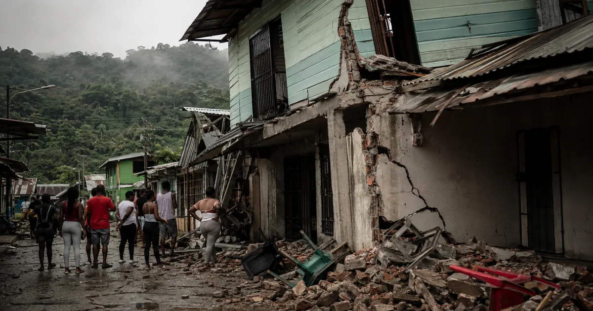
What broke tells the same story. Chocó Governor Nubia Carolina Córdoba-Curi told CBS News there were injuries and significant damage to buildings in Quibdó, the departmental capital of about 130,000 people. The governor of neighboring Risaralda reported serious damage to some buildings in Pereira. Local outlets circulated footage of homes and small structures coming down in Pereira, Cali, and Quibdó, and a neo-Gothic cathedral tower gave way in Manizales.
In Bogotá, where crowds spilled into the streets, Mayor Carlos F. Galán said no structural damage had been reported there. Taken together it describes a country that felt the earthquake almost everywhere and lost buildings in relatively few places.
Note what the failures have in common. A cathedral tower, older homes, small structures. Deep-focus shaking finds the weakest construction in a very large area rather than destroying everything in a small one, which means the damage list is really a map of where the building stock was already marginal.
Chocó Is the Part to Watch
Here is the thing the magnitude number will not tell you, and the reason to keep watching this story past Monday.
Of every department this earthquake could have centered on, it centered on Chocó. Chocó is consistently Colombia’s poorest department, majority Afro-Colombian and Indigenous, and the one with the thinnest state presence of any in the country. Quibdó is not a place emergency convoys drive to easily. Road access into the department is limited and unreliable, which is a chronic complaint in ordinary weeks and a genuine constraint in the seventy-two hours after a disaster, when reaching the injured is the entire job.
So the honest read is this: the seismology was merciful and the geography was not. The final toll from Monday will be set less by what the fault did than by how fast the Colombian state can get people and equipment into a region it has historically underserved. That is a question about institutional capacity and political priority, not about tectonics, and it is the question worth asking of officials in the coming days.
There is a version of the next week where the deep rupture means this ends as a bad scare with a manageable injury count. There is another version where damaged structures in Quibdó and unreachable communities around the epicenter turn a survivable earthquake into something worse through sheer slowness. Both are still live.
A New President’s First Disaster
The response also lands on an administration that has barely started. President Abelardo de la Espriella, who won Colombia’s runoff in June on a hard-line law-and-order platform, convened an emergency meeting with the disaster management agency and said he would personally supervise recovery efforts and install an emergency command center in San José del Palmar.
Going to the epicenter is the correct instinct and also the easy part. The harder test is whether the machinery underneath the president can sustain a logistics operation into Chocó for weeks rather than staging a visible forty-eight hours. Disaster response is one of the few functions where a government’s actual administrative competence becomes visible almost immediately, and every new administration eventually gets graded on one. De la Espriella got his in his first weeks.
The BBC’s early report from the region and the assessments still coming in from the disaster agency will firm up over the next day. Until then, the most important unknown is not how strong the earthquake was. It is how far into Chocó anyone has actually gotten.