
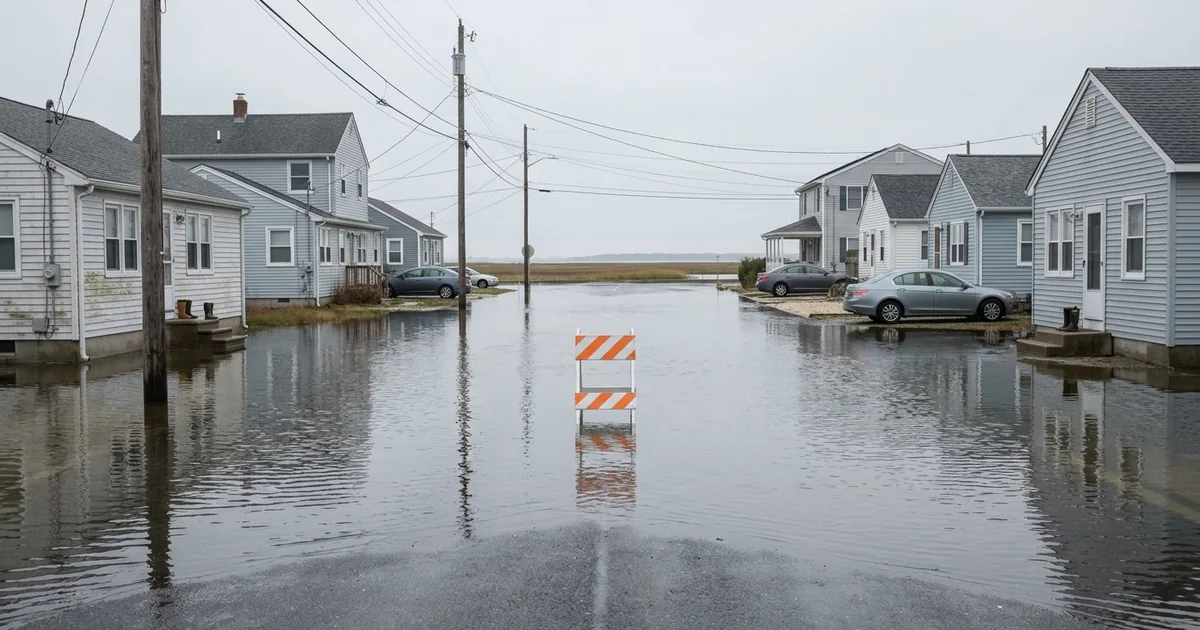
Governor Kathy Hochul declared a state of emergency on Friday evening for eight New York counties as a nor’easter pushed more than 31 million people along the East Coast under coastal flood warnings and advisories, and her order names the same eight counties, in the same sequence, as the one she signed eleven months ago.
What is established as of Friday night:
- Hochul’s declaration covers Bronx, Kings, Nassau, New York, Queens, Richmond, Suffolk and Westchester counties.
- New Jersey Governor Mikie Sherrill signed Executive Order No. 25, effective 5 p.m. Friday, covering Atlantic, Burlington, Cape May, Cumberland, Middlesex, Monmouth, Ocean and Salem counties.
- Forecasters expect gusts to 60 mph, 4 to 6 inches of rain Saturday into Sunday, and 1 to 4 feet of coastal inundation.
- A full moon Saturday night is expected to lift already elevated tides another 5 to 6 inches.
- The worst conditions arrive Saturday through Saturday night.
What the Coverage Is Not Doing
Nearly every national outlet is running this storm as a meteorological curiosity, a rare fall nor’easter that showed up on the calendar four months early. That framing is accurate and it is also doing a lot of work. Nobody has put the emergency declarations themselves side by side with the ones from last autumn, which is where the actual finding is: New York’s order is a verbatim repeat, and New Jersey’s is the opposite, a deliberate narrowing from the whole state down to eight counties. Two governments read the same ocean this week and drew opposite administrative conclusions from it. One of them is learning. The other is filing the same paperwork.
New York’s List Has Not Moved in Eleven Months
On October 12, 2025, Hochul declared a state of emergency during a coastal storm covering, in the language of her own announcement, “Bronx, Kings, Nassau, New York, Queens, Richmond, Suffolk and Westchester Counties.”
On Friday, she declared another one. The counties: “Bronx, Kings, Nassau, New York, Queens, Richmond, Suffolk and Westchester Counties.”
Same eight. Same order. Same punctuation.
This is not sloppiness, and reading it that way misses the point. The list is identical because the exposure is identical. Every one of those eight jurisdictions sits on the same low-lying back-bay and barrier-beach geography that takes the water whenever a strong northeast flow stacks the Atlantic against the shoreline, and not one thing about that geography changed between the two storms. The declaration is a faithful description of where the vulnerability is. What it is not is evidence that anything happened in between.
Hochul’s office says the state has 5,675 workers positioned for response and restoration this weekend, with 175 Con Edison mutual aid contractors, 3,375 Department of Transportation supervisors and operators, and swift water rescue teams pre-staged. That is a serious mobilization. It is also entirely downstream of the flooding.
New York, Then and Now
October 2025: Bronx, Kings, Nassau, New York, Queens, Richmond, Suffolk, Westchester.
September 2026: Bronx, Kings, Nassau, New York, Queens, Richmond, Suffolk, Westchester.
Change in eleven months: none.
New Jersey, Then and Now
October 2025: all 21 counties, under Executive Order No. 399.
September 2026: eight counties, under Executive Order No. 25.
Change in eleven months: a statewide order replaced by a targeted one.
New Jersey Narrowed Its Map
Last October, with Governor Phil Murphy out of state, Acting Governor Tahesha Way signed Executive Order No. 399 and put all 21 New Jersey counties under a state of emergency for a nor’easter forecast to bring sustained winds near 60 mph and up to five inches of rain.
This week Sherrill went the other way. Her order names eight counties and says why: “Starting tonight, this nor’easter is expected to bring damaging winds, heavy rain, significant coastal flooding, and resulting beach erosion, with these eight counties facing the greatest risk.” Six of the eight are coastal or bayfront. Middlesex and Burlington carry the tidal reaches of the Raritan and the Delaware.
A statewide declaration is the safer political instrument, because no county can complain it was left out. A targeted one is the more useful governing instrument, because it tells the State Emergency Operations Center and 21 county emergency managers where to send equipment that only exists in finite quantities. Sherrill picked the harder and better option. Hochul, whose order sweeps in all five boroughs including the Bronx, has not made that distinction in two consecutive storms.
The Water Arrived Before the Storm Did
The flooding did not wait for the declarations. Days of onshore northeast winds had already pushed Atlantic water into the lower Chesapeake Bay and its tidal rivers before the storm’s core moved north, and by Thursday dozens of streets across Norfolk, Virginia Beach and Suffolk were under water. In some neighborhoods, 13News Now reported, one high tide had not drained before the next one arrived, leaving streets submerged for hours. Dominion Energy counted roughly 8,000 customers without power across Hampton Roads and northeastern North Carolina at Thursday morning’s peak.
That sequence is the part worth holding onto. The surge was building for days out of ordinary wind, before a single emergency order was signed, which is what a chronic condition looks like as opposed to an acute one.
Why It Is Always These Counties
Nor’easters do their damage through duration rather than peak intensity. A hurricane makes landfall and moves on in hours. This system is forecast to grind against the same stretch of coast across four consecutive high tides, and each one arrives before the previous one has fully drained, so the baseline creeps up. Add a full moon Saturday night worth another 5 to 6 inches of tide, per the latest NBC News forecast, and 1 to 4 feet of inundation stops being a number on a map and becomes water in a ground-floor apartment in Broad Channel or Highlands.
The counties repeat because the map of who is exposed is fixed and the map of what has been built to protect them is nearly static. Barrier-island communities and back-bay neighborhoods flood on a schedule set by the tide chart. Everyone who works in coastal emergency management knows precisely which streets go first. They are the same streets every time, which is why the same county names keep appearing in the same documents.
A Declaration Is a Response Tool, Not a Repair
Here is where this site comes down. Both governors were right to declare, and the pre-staging Hochul described is exactly what a state should do with 24 hours of warning. But an emergency declaration that reproduces its predecessor word for word is a receipt, and what it is a receipt for is a problem nobody fixed in the intervening year.
The instrument is doing its job. It moves crews, unlocks money, and clears procurement. It is not designed to raise a road, buy out a repeatedly flooded block, restore a dune, or upsize a tide gate, and no volume of swift water rescue teams substitutes for any of that. New York issued an identical order eleven months apart and has not published anything resembling a matching commitment for those same eight counties. That gap is a choice, and it is the one worth pressing an elected official on once the water goes down, rather than the question of whether a September nor’easter is unusual.
Sherrill’s narrowing points at the better practice. She had to decide which eight counties carried the real risk and defend it in writing. That is a governor being specific in public, and specificity is what makes a document auditable later. New York should be made to do the same.
What Saturday Night Actually Tests
The weekend will produce the usual accounting: outage counts, a flooded-road tally, cancelled events that already include the Global Citizen Festival in Central Park, All Things Go in Queens, and AC/DC at MetLife Stadium. Hochul’s instruction to New Yorkers was four words long. “Take this storm seriously.”
The number that matters is not any of those. It is whether the eight counties named Friday are the same eight named in the next declaration, because that is the only measure of whether this weekend changed anything.
The Order That Comes Next
There will be another one. Nor’easter season formally runs into April, and this storm arrived ahead of it rather than in place of it. When the next order is signed, read the county list before the forecast. If it is identical again, the storm was never the variable.