
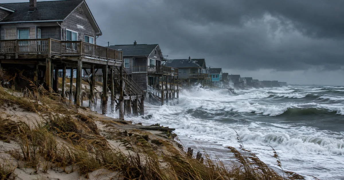
The first nor’easter of the fall is strengthening off the East Coast and will push several days of coastal flooding, heavy surf and 40 mph gusts from North Carolina to southern Maine through the weekend.
- The storm arrives alongside Saturday’s Harvest full moon, so astronomical tides are already running high before any wind is added.
- Water levels are forecast 2 to 3 feet above the average monthly tide, with some locations approaching 6 feet.
- The National Weather Service has coastal flood warnings up across the mid-Atlantic, with the longest duration on eastern Long Island and the Massachusetts coast.
- In Buxton, North Carolina, 32 homes have collapsed into the Atlantic since 2020. Twenty of them went between September 2025 and June 2026.
That last bullet is not in most of the forecast coverage, and it is the one that decides what this storm actually means.
Two Ways to Report the Same Storm
There are two entirely accurate stories available here, and almost every outlet has run the first one.
The weather story. A strong coastal low, unusually potent for September, coinciding with king tides. Dune washovers, boardwalk damage, beach erosion, scattered power outages. AccuWeather’s chief meteorologist says it may be remembered for destructive coastal flooding. It clears by early next week and the forecast pages go stale.
The ledger story. Dare County and its oceanfront towns have spent more than $275 million on beach nourishment, largely without state or federal help. Rodanthe is losing more than 15 feet of shoreline a year. Highway 12, the only road onto Hatteras Island, closes in minor storms. This weekend is an installment, not an event.
“Beach erosion” is the phrase that lets the second story hide inside the first.
It sounds like a process. Sand moves, sand comes back, the dunes take a beating and get rebuilt. Seasonal. Managed.
On Hatteras Island it is not a process. It is a slow demolition with a schedule, and the buildings have been coming down on camera for six years.
What $275 Million Buys
Dare County has been paying for its own coastline. By the county’s own accounting, more than $275 million has gone into nourishment projects and inlet maintenance, and its message to state leaders this year was a request that somebody else start helping.
The current Buxton project is just under $40 million and covers 2.9 miles of beach.
Nourishment works. That is the uncomfortable part. Pump sand onto a beach and you get a wider beach, protection for the road, and a functioning tourist economy for a while.
The problem is the word “while.” A single stretch near Rodanthe has been re-funded three separate times in the last decade. Each round buys years, not decades, and each round costs more than the last as the sand gets harder to source and the storms arrive on a shorter interval.
So a county of fewer than 40,000 year-round residents is renting its own geography, in installments, at a price that rises every renewal.
That is not a coastal management strategy. It is a subscription.
The Retreat Nobody Will Say Out Loud
The alternative has a name that no elected official in a beach community wants to use, which is managed retreat: buying out the most exposed properties, moving or demolishing the structures, and letting the shoreline go where it is going anyway. Coastal Review put the case plainly back in March, after the thirty-first house went in.
Buxton has already started doing it without calling it that. Homes are being moved back from the water. Others are being torn down. Dare County tried to buy one house for removal and it collapsed before the purchase closed.
Here is where LiveNewsChat lands, and it is not a comfortable position for anyone involved.
The nourishment money is not wasted, but it is being spent as a substitute for a decision rather than a bridge to one. Nobody has said how many more rounds Hatteras gets, what the trigger is for stopping, or which properties are inside the line and which are outside it.
Without those answers, every dollar of sand is an implicit promise to the next owner that the beach will be defended, and that promise is not one Dare County can keep on its own budget.
The state of North Carolina has let a small county carry a nationally significant coastline and a federally designated national seashore by itself. That is the failure worth naming. Highway 12 is not a local amenity. It is the access road to Cape Hatteras National Seashore and the only evacuation route for everyone living south of Oregon Inlet, and it is being protected by a county property tax base.
The federal picture is not better. FEMA’s staffing fights have been running through this hurricane season, and a response agency in litigation over whether it has enough people is not an agency prepared to absorb a long-horizon coastal retreat program.
What To Actually Do This Weekend
None of that helps anyone who lives there on Saturday, so the practical version is short.
If you are on Hatteras, assume Highway 12 closes. It usually does, and the closure is what strands people rather than the water itself.
Check tide times rather than storm times. The damage windows are at high tide, and with the Harvest moon the two highest cycles of this storm land Saturday and Sunday.
Do not go look at the surf. The most reliably fatal part of a nor’easter is the rip currents and the people who drive to the beach to photograph them.
And for everyone watching from the mainland: the houses that go into the ocean this weekend, if any do, will generate a round of drone footage and a round of arguments about whether the owners should have built there.
Both of those are a distraction from the actual question, which is who pays for the shoreline of a national seashore, and when somebody is finally going to answer it in public.